


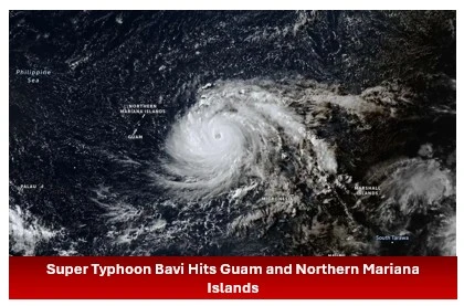
Super Typhoon Bavi swept across the U.S. Northern Mariana Islands and Guam in early July 2026, bringing destructive winds, heavy rainfall, and dangerous storm surge. After reaching peak intensity near the islands, the powerful storm continued westward over the Philippine Sea with forecasters monitoring its possible path toward Taiwan, southern Japan, and mainland China.
Bavi Reached Peak Strength Near Guam
Super Typhoon Bavi approached Guam and the U.S. Northern Mariana Islands on the night of July 5, packing winds of 290 kilometers (180 miles) per hour along with torrential rain and significant storm surge.
It marked the second powerful typhoon in three months to cross the islands.
A nighttime image captured by the VIIRS (Visible Infrared Imaging Radiometer Suite) aboard the NOAA-20 satellite recorded the storm’s eye at approximately 15:30 Universal Time on July 5, equivalent to 1:30 a.m. local time on July 6. Moonlight from the waning gibbous Moon illuminated the western side of the eyewall, while the eye later passed over Rota, located north of Guam.
Read more: Wayanad Landslide Raises Safety and Infrastructure Concerns in Kerala
Warm Ocean Waters Fueled Rapid Intensification
Bavi strengthened into a super typhoon during the early hours of July 4 (local time) while moving west across exceptionally warm ocean waters.
Satellite observations showed sea surface temperatures of around 30 degrees Celsius (86 degrees Fahrenheit) in the region, conditions favorable for rapid intensification.
The storm became the third tropical cyclone of 2026 to achieve Category 5 intensity on the Saffir-Simpson wind scale.
Read more: Heavy Rain Cuts Mumbai-Pune Connectivity as Landslides Halt Trains Close Expressway
Extensive Damage Reported Across the Islands
News reports indicated widespread destruction across Guam, Rota, and Saipan.
The typhoon:
- Knocked down power poles and electrical lines.
- Flooded roads and scattered debris across transportation routes.
- Damaged multiple buildings, including a water distribution station on Rota.
Following the storm, U.S. Coast Guard crews worked to remove navigation hazards from waterways around Guam and the Northern Mariana Islands and reopen ports after dangerous marine conditions eased.
The latest damage adds to the destruction already caused by Super Typhoon Sinlaku, which struck the islands in mid-April with powerful winds and flooding.
Typhoon Continues Across the Philippine Sea
By July 8, Bavi remained a powerful typhoon while tracking west over the Philippine Sea.
The National Weather Service reported maximum sustained winds of 250 kilometers (155 miles) per hour during the early afternoon when updated satellite imagery was captured.
Forecasts suggested the storm could gradually turn northwest toward Taiwan, the Ryukyu Islands of southern Japan, and mainland China, while weakening over the following several days.
Meteorologist Links Storm Pattern to Developing El Niño
Meteorologist Jeff Masters, writing in Yale Climate Connections, said Bavi reflects the type of storm that can develop as a strong El Niño builds.
Masters explained that typhoons during El Niño years often form farther east, allowing them to remain over warm ocean waters for a longer period before curving toward Asia, “resulting in a greater chance of reaching Category 5 intensity.”
Conclusion
Super Typhoon Bavi became one of the strongest tropical cyclones of 2026 after striking Guam and the Northern Mariana Islands with destructive winds and heavy rainfall. While recovery efforts continue across the affected islands, meteorologists are closely monitoring the storm as it moves across the Philippine Sea with a potential track toward Taiwan, southern Japan, and mainland China.
